


GNSS View
Description of GNSS View
GNSS View is an Android application designed for users to visualize the positions of various global navigation satellites, including the Quasi-Zenith Satellite System (QZSS) and Global Positioning System (GPS). This app allows users to access satellite positioning information based on publicly released orbit data, making it a useful tool for those interested in satellite tracking and positioning technology.
The application features several key functionalities, including a Position Radar and Augmented Reality (AR) Display. The Position Radar screen provides a radar view of the positioning satellites, displaying their arrangement in the sky at a specified time and location. Users can specify the type of satellites they wish to view, including QZSS, GPS, GLONASS, BeiDou, Galileo, and SBAS. The radar also offers options to turn on or off the display of satellite numbers, control the rotation of the display, and specify an elevation mask angle for selected satellites.
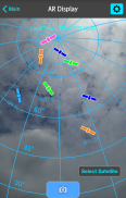
In addition to the Position Radar, the AR Display feature enables users to see the positions of the satellites through their Android device's camera. This real-time visualization helps users understand where the satellites are located in relation to their current position. To utilize this feature, users must enable the position information on their smartphone and complete the positioning process, which may take some time before the satellites are displayed.
GNSS View also allows users to view essential positioning data, including Horizontal Dilution of Precision (HDOP) and Vertical Dilution of Precision (VDOP). This information can assist users in assessing the accuracy of the satellite signals they are receiving. Additionally, the application provides data on the total number of satellites in view and the number of each type of positioning satellite, contributing to a comprehensive understanding of the satellite environment.
The app is compatible with a wide range of Android versions, ensuring that users with different devices can access its features. It supports Android versions from 6 through 14, making it versatile and accessible for many users.
For those interested in the technical aspects of satellite positioning, GNSS View offers an intuitive interface that facilitates the exploration of satellite data. Users can move between the main screens, including the Position Radar and AR Display, easily navigating through the application. The inclusion of an operating manual and privacy policy is also available through the app’s website, providing users with additional information about its functionality and data handling practices.
The Quasi-Zenith Satellite System, often referred to as the Japanese GPS, represents a significant advancement in satellite positioning technology. By allowing users to visualize satellites in the sky, GNSS View enhances the understanding of how these systems work and their relevance in various applications, from navigation to surveying.
As users interact with the app, they will find that the ability to select specific types of satellites and adjust settings according to personal preferences enhances their experience. The capability to filter satellite signals and adjust the elevation mask angle allows for a tailored view, making it easier to focus on the most relevant data.
Moreover, the AR Display feature stands out as a practical tool for visual learners and those who benefit from seeing real-world applications of satellite technology. By combining digital information with the physical world, GNSS View bridges the gap between abstract concepts and tangible observations.
Educational institutions, surveyors, and enthusiasts alike may find GNSS View to be a valuable resource. By offering insights into the positioning satellites above, the app promotes a deeper understanding of satellite navigation and its implications in various fields.
For anyone interested in downloading this application, GNSS View is readily available for the Android platform, ensuring that users can easily access its features and begin exploring satellite positions.
In essence, GNSS View serves as an informative tool for anyone looking to better understand satellite positioning systems. By providing users with the ability to visualize satellite arrangements and access essential positioning data, it supports both casual users and those with more advanced technical interests. The combination of its Position Radar and AR Display features offers a unique approach to satellite tracking, making GNSS View a noteworthy application in the realm of navigation technology.
For further details on the Quasi-Zenith Satellite System, visit the official website: https://qzss.go.jp/en.
GNSS View - APK Information
APK Version: 5.0.3Package: com.nec.android.qzss.gnssviewLatest Version of GNSS View
Other versions


Apps in the same category

You may also like...


